The Standard Map
Civilization: The Expansion Project comes with huge map covering the Iberian pensulia to the Indian subcontinent. It is availible in three different graphical styles, to please all different tastes. The game technical data is the same on all of them.
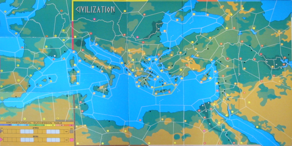
Martin's Mapboard (with area names)
.png)
This is the official map, and is the only map suitable for play by email. Having the area names on the map also simplifies using the Scenario Hanbook to determine playable area for games with less than 18 players.
Martin's Mapboard (without area names)
-NoAreaNames.png) This is the same mapboard as above, but without area names. For those of you wanting a "cleaner"
look.
This is the same mapboard as above, but without area names. For those of you wanting a "cleaner"
look.
Mark's Mapboard Redux
.png)
This is Mark's Mapboard Redux. It looks great, but is a large download, and lacks area names. Only intended for printing.
NB: Not yet updated with the 2.09 map and AST changes.
Counters and Playermats
The standard mapboard comes with 18 national playermats and 18 sets of national counters as well as an extra set of counters for barbarian tokens and pirate cities.
Scenario Handbook for the Standard Map
The Scenario Handbook for the Standard Map contains all map specific information needed when playing with the Standard Map.
The Avalon Hill® Civilization® Map
You can also use the map from Civilization® by Avalon Hill® when playing Civilization: The Expansion Project. However, using it for Civilization: The Expansion Project is not quite as balanced, and it can only host a maximum of 9 players (with the Western Extension Map).
Playermats and Counters
When playing on the Civilization map please use the counters that came with Civilization. Work on playermats for the Avalon Hill Civilization Map is still in progress. In the meantime, please use the playermats for the standard mapboard, and ignore the nation specific parts.
Scenario Handbook for the Avalon Hill® Civilization® Map
Work on The Scenario Handbook for the Avalon Hill® Civilization® Map is still in progress. It will eventually tell you all you need to play Civilization: The Expansion Project on the Civilization map, but for now your common sence will have to do.
The Far East Mapboard
There is also work on a mapboard of China and Southeastern Asia. It is not yet completed, but will be included here when it is.
Credits
The Mediterranean area is based on the American (Avalon Hill) map for Civilization (incl. the Western Expansion Map).
The Persia/Arabia graphical section is partially based on an add-on from the Spanish magazine Alea. To those thinking of buying issue #21 of Alea just for this map... DON'T. While the map looks good there are simply way to many errors on the American (Avalon Hill) version of the map, regions didn't have population markers and some regions bordered diagonally (which is just confusing). We had to spend hours and hours to fix it. It most certainly wasn't play tested (unless they messed up the map at printing).
Velusion is primarily responsible for the Horn of Africa.
India and Northern Europe was mostly done by Martin Brodén.
Martin Brodén also remade the entire map into one nice streamlined vector PDF. Without his effort the map would not look as great as it does!
Mark Mahaffey made a redux of Martin's map, looking awesome. It is part of his map redux odyssey, you can see his complete portfolio at west2productions.com/Mapology.
- John Rodriguez (Velusion) and Jon Severinsson (Jonno)